| he weather forecast has gotten worse, that is, unless you like lots and lots of snow.
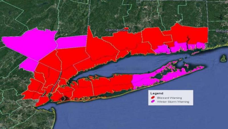
Early Monday morning, the National Weather Service posted a blizzard warning for Fairfield and New Haven counties from midnight Tuesday to midnight Wednesday.
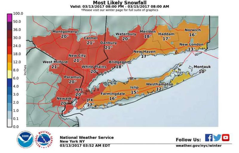
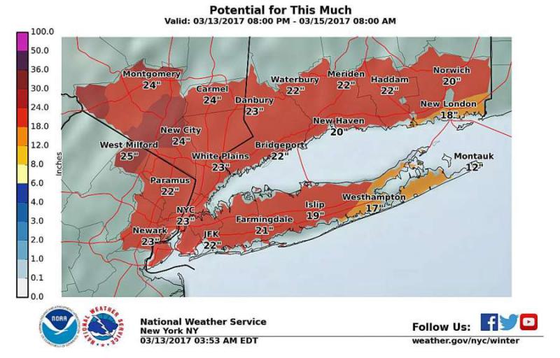
It also increased the projected snowfall accumulation to 18 inches to two feet, a half-foot higher than Sunday’s projection. It expects snowfall rates to be 2 to 4 inches per hour early Tuesday morning into Tuesday afternoon it said it its latest storm briefing.
“Dangerous whiteout conditions at times ... several roads may become impassable ... power outages possible,” it says in the blizzard warning that was issued at 4:18 a.m. Monday. “Falling and blowing snow with strong winds and poor visibilities are likely ... this will lead to whiteout conditions with visibilities one quarter-mile or less at times.... making travel extremely dangerous. Do not travel. If you must travel ... have a winter survival kit with you. If you get stranded...stay with your vehicle.”
The powerful nor’easter is on track to hit Connecticut bringing heavy snow, strong winds that will likely paralyze the state Tuesday.
State Department of Transportation and local public works crews are mobilzing for what could be the biggest March stormstorm in memory. The state snowfighting force will have 634 trucks on the road along with 250 contractor plows and 15 industrial snowblowers that can throw snow off of bridges and elevated sections of highways.
“This is going to be a lot of snow very quickly,” said DOT spokesman Kevin Nursick. “Unless it’s an emergency situation, people should stay off the road Tuesday. You’re not going to see three feet in front of your vehicle, you won’t see the shoulder or the snow plow. There will be 50 mph winds and very low visibility. This storm is no joke.”
The heavy snow and winds also strong as 41 mph could cause widespread power outages. Eversource says its preparing for tree-related damage to its electric system and will have crews and support staff ready to respond. Customers are encouraged to also prepare for the possibility of outages.
“We design and build our system to stand up to the effects of storms like this and our staff will be ready to address any damage the snow and winds might cause,” said Mike Hayhurst, Vice President of Electric System Operations at Eversource. “We’re confident our ongoing system improvements and tree maintenance program, combined with our strategic emergency response plan, will enable us to safely and efficiently handle any issues that may arise.”
Here’s what you need to know:
When will the snow start and end?
The NWS says snow is expected “mainly after 10 p.m.” with up to 3 inches overnight.
Its hourly forecast says there is a 58 percent chance of snow falling at 2 a.m., rising to 86 percent at 5 a.m. Tuesday. It says snow will likely be falling during a 12-hour period, from 5 a.m. to 5 p.m. Tuesday.
There is a 100 percent chance of snow with 12 to 18 inches possible falling through the day Tuesday
Steady snow will taper off to snow showers around 8 p.m. .
This will not be like the pretty, slow-falling snow that we saw last Friday. Instead, it will be a wind-driven snow that will reduce visibilities and create drifts several feet deep.
What’s the definition of a blizzard?
A blizzard means that the following conditions are expected to prevail for a period of three hours or longer:
Sustained wind or frequent gusts to 35 miles an hour or greater; and considerable falling and/or blowing snow (i.e., reducing visibility frequently to less than quarter mile).
Will there be any mixed preciptation with this storm?
Not this time. For southwest Connecticut it will be an “all snow event.” The NWS says the areas that could seen any mixed precipitation are in southeast Connecticut and Long Island.
Closings and delays
It’s likely most schools will be closed Tuesday.
Although no announcement has been made yet, it’s also likely Gov. Dannel Malloy will allow “non-essential” state workers to take the day off.
That last time he did that was on Feb. 9 when more than a foot of snow fell across the site. At the time, he said: “"We need roads clear so that emergency personnel and utility crews can do their job. As such, I urge all Connecticut residents to stay off the roads unless absolutely necessary. If employers can allow people to work from home or alter their hours, I encourage them to do that as well."
With travel expected to be difficult - and dangerous - many people will be working from home or take the day off. Today, is the day to arrangeTuesday work options with your boss.
Don’t expect all stores, banks and businesses to be open.
Monday’s weather will be sunny with a temperature just below freezing. Today is the day to get your storm preparations done before the snow moves in tonight.
Will roads be closed?
With the blinding snow expected, road closings may not need an executive order from the governor.
Generally, Malloy does not order does an overall ban on highway driving.
But, on Jan 27, 2011, he authorized the first truck ban on Connecticut highways since the blizzard of 1996 when then-Gov. John G. Rowland ordered the state's major arteries closed to tractor-trailers in preparation for a weather bomb dropping 16 inches of snow. The ban came series of accidents on I-95 in Darien that took five hours to clear.
That ban on highway truck travel was controversial. Truckers denounced it. Commuters praised it. But it proved to be a five-hour pause between three early-morning truck crashes and four more that occurred shortly after the ban was lifted.
There have also been other restrictions such as banning tractor-trailer trucks on highways on certain times to allow snow-removal crews to do their work. And, the Merritt and Wilbur Cross parkways have been shut down during previous storms because of concern of falling trees.
Both State Police and officials have said that many people have heeded the advice to stay off the roads in prior storms.
With snow falling up to 4 inches per hours, road crews will have an extremely difficult time keep roads clear. State officials warn that even with the full fleet of snow removal equipment deployed throughout the state, keeping the roads clear during such a heavy snow fall will be a challenge.
Will there be any coastal flooding?
There is a coastal flood watch for the Long Island Sound shoreline for Fairfield County.
Tides will be between two to three feet higher than normal. “Widespread flooding of vulnerable shore roads and/or basements due to the heigh of the storm tide and/or wave action,” the NWS says.
How strong will the wind be?
It will be blowing from the northeast at 22 to 30 mph, with gusts as high as 41 mph.
This could lead to widespread power outages?
Wind will continue Tuesday night, shifting from the northwest between 20 to 25 mph decreasing to 9 to 14 mph after midnight.
How cold will it get?
Temperatures will be cold all week with evening readings in the 20s and teens.
Is this an average winter for snowfall?
Most areas of southwest Connecticut have already had their average snowfall for the winter.
Bridgeport has surpassed its seasonal average snowfall by more than 10 inches. From December through March 10, Bridgeport had 33.8 inches; the yearly average is 23.7 inches.
Since the 21st century began, Bridgeport’s snowiest winters were 64.3 inches in 2012-13; 64 inches in 2002-03; 62.6 in 2010-11; 59.7 in 2014-15 and 57.4 in 2013-14. In the winter 0f 2001-02, only 8.5 inches of snow fell.
What are the snowfall forecasts from Conneticut meteorologists?
Ryan Hanrahan, NBC Connecticut, “Over 6" of snow is extremely likely with over 12" of snow now a good bet. Current forecast is 12"-18" of snow statewide with locally higher amounts to 24" - especially in the hills. Snow begins around daybreak with the heaviest snow between 10 a.m. and 8 p.m. This time table may change a couple hours in either direction.”
Scott Haney, WFSB, “"Snow should begin in southwestern Connecticut first, then quickly develop northeast, sometime around dawn [Tuesday]. From there, it's expected to be heavy at times. The wind will also pick up during the morning. The afternoon will also be snowy and windy, with sometimes heavier snow," Haney said. "There will likely be bands of heavier snow, which will mean some areas will be favored for more snow than others." Haney said it was difficult to pinpoint where those areas would be. In regard to the 10 to 20 inches of snow that's predicted, there could be higher amounts in areas where the bands of higher snow rates concentrate.
Gil Simmons, WTNH, is forecasting 15 to 25 inches across the western two-thirds of Connecticut. “The higher totals will be under any slow moving convective bands. Thunder snow even possible!”
Connecticut Weather Center in Danbury, “Snowfall 16-20 inches with up to two feet locally. Drifts two to five feet.”
http://www.greenwichtime.com/local/article/Blizzard-warning-issued-with-higher-snow-totals-10997255.php#photo-12538696 |